
Potrerillos topographic map
Interactive map
Click on the map to display elevation.
About this map
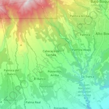
Name: Potrerillos topographic map, elevation, terrain.
Location: Potrerillos, Distrito Dolega, Chiriquí, Panama (8.64911 -82.52938 8.77737 -82.44996)
Average elevation: 3,652 ft
Minimum elevation: 1,601 ft
Maximum elevation: 8,517 ft
Other topographic maps
Click on a map to view its topography, its elevation and its terrain.
Rovira
Panama > Chiriquí > Distrito Dolega
Rovira, Distrito Dolega, Chiriquí, Panama
Average elevation: 3,310 ft