
Chandel topographic map
Interactive map
Click on the map to display elevation.
About this map
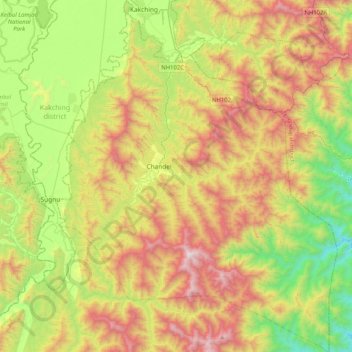
Name: Chandel topographic map, elevation, terrain.
Location: Chandel, Manipur, 795127, India (24.13407 93.88062 24.50667 94.20862)
Average elevation: 3,169 ft
Minimum elevation: 994 ft
Maximum elevation: 6,224 ft
Other topographic maps
Click on a map to view its topography, its elevation and its terrain.
Tengnoupal
India > Manipur > Tengnoupal tehsil
Tengnoupal, Tengnoupal tehsil, Tengnoupal District, Manipur, India
Average elevation: 4,003 ft
Loktak Lake
India > Manipur > Bishnupur > Thanga
Loktak Lake, Thanga, Bishnupur, Manipur, India
Average elevation: 2,533 ft
Imphal
India > Manipur > Lamphelpat
Imphal, Lamphelpat, Imphal West District, Manipur, 795001, India
Average elevation: 2,825 ft