
غمراسن topographic map
Interactive map
Click on the map to display elevation.
About this map
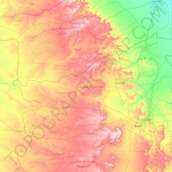
Name: غمراسن topographic map, elevation, terrain.
Location: غمراسن, Tataouine, Tunisia (32.92312 9.89355 33.16940 10.60732)
Average elevation: 1,132 ft
Minimum elevation: 282 ft
Maximum elevation: 2,119 ft
Other topographic maps
Click on a map to view its topography, its elevation and its terrain.
Remada
Tunisia > Tataouine > رمادة الشرقية > Remada
Remada, رمادة الشرقية, معتمدية رمادة, Tataouine, 3240, Tunisia
Average elevation: 968 ft
Ghomrassen
Ghomrassen, الواحة, معتمدية غمراسن, Tataouine, 3220, Tunisia
Average elevation: 1,066 ft