
Kozaklı İlçe Merkezi topographic map
Interactive map
Click on the map to display elevation.
About this map
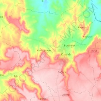
Name: Kozaklı İlçe Merkezi topographic map, elevation, terrain.
Average elevation: 3,556 ft
Minimum elevation: 3,159 ft
Maximum elevation: 3,839 ft
Kozaklı, formerly Hamamorta and Kisla, is a town in Nevşehir Province in the Central Anatolia region of Turkey. It is the seat of Kozaklı District. Its population is 7,589 (2022). Located in Cappadocia, its average elevation is 1,041 m (3,415 ft). Due to its central situation to the nearest larger cities like Nevşehir, Kayseri, Yozgat, Niğde and Kırşehir (within 100 km (62 mi) distance), and particularly due to its natural spas, hamams and hotel facilities, Kozaklı has been a popular resort in Central Anatolia.