
Rutland topographic map
Interactive map
Click on the map to display elevation.
About this map
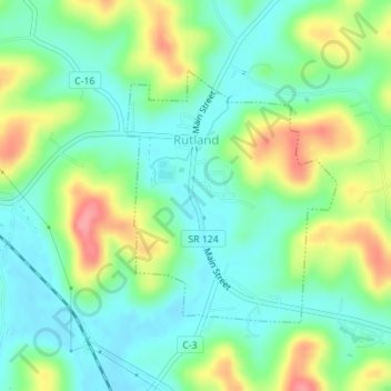
Name: Rutland topographic map, elevation, terrain.
Location: Rutland, Meigs County, Ohio, United States (39.03272 -82.13663 39.05014 -82.11788)
Average elevation: 663 ft
Minimum elevation: 561 ft
Maximum elevation: 860 ft
Other topographic maps
Click on a map to view its topography, its elevation and its terrain.
Pomeroy
United States > Ohio > Meigs County
Pomeroy, Meigs County, Ohio, United States
Average elevation: 686 ft
Hemlock Grove
United States > Ohio > Meigs County
Hemlock Grove, Meigs County, Ohio, 45776, United States
Average elevation: 748 ft
Chester
United States > Ohio > Meigs County
Chester, Meigs County, Ohio, 45720, United States
Average elevation: 725 ft
Keno
United States > Ohio > Meigs County > Keno
Keno, Meigs County, Ohio, 45743, United States
Average elevation: 699 ft