
Angol topographic map
Interactive map
Click on the map to display elevation.
About this map
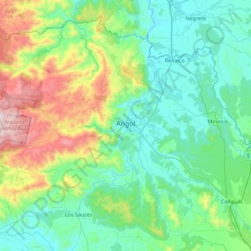
Name: Angol topographic map, elevation, terrain.
Location: Angol, Provincia de Malleco, Araucanía Region, Chile (-38.02399 -73.12443 -37.58180 -72.48214)
Average elevation: 1,086 ft
Minimum elevation: 157 ft
Maximum elevation: 4,698 ft
Other topographic maps
Click on a map to view its topography, its elevation and its terrain.
Malleco
Chile > Araucanía Region > Provincia de Malleco > Angol
Malleco, Angol, Provincia de Malleco, Araucanía Region, 4650000, Chile
Average elevation: 285 ft