
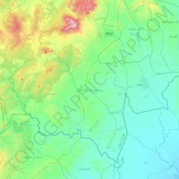
معتمدية الناظور topographic map
Interactive map
Click on the map to display elevation.
About this map
Name: معتمدية الناظور topographic map, elevation, terrain.
Location: معتمدية الناظور, Zaghouan Governorate, Tunisia (36.00057 9.83820 36.22296 10.17409)
Average elevation: 794 ft
Minimum elevation: 174 ft
Maximum elevation: 3,215 ft
Other topographic maps
Click on a map to view its topography, its elevation and its terrain.
Zaghouan
Tunisia > Zaghouan Governorate > زغوان المدينة
Zaghouan, زغوان المدينة, معتمدية زغوان, Zaghouan Governorate, 1100, Tunisia
Average elevation: 827 ft
Sawwaf
Tunisia > Zaghouan Governorate > صواف الغربية > Sawwaf
Sawwaf, صواف الغربية, معتمدية صواف, Zaghouan Governorate, Tunisia
Average elevation: 548 ft