
Florina topographic map
Interactive map
Click on the map to display elevation.
About this map
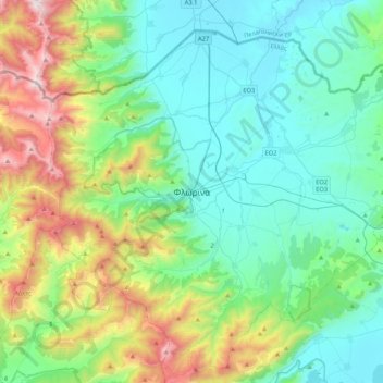
Name: Florina topographic map, elevation, terrain.
Average elevation: 3,278 ft
Minimum elevation: 1,883 ft
Maximum elevation: 7,608 ft
Florina is one of the coldest towns in Greece, because of its elevation and geographic position. Heavy snowfalls, thick fog and below-freezing temperatures are common during the winter months, while the summers are mild. Under the Köppen climate classification, Florina has a humid subtropical climate (Cfa) with strong hot-summer continental climate (Dfa) influences.
Other topographic maps
Click on a map to view its topography, its elevation and its terrain.
Pisoderi
Greece > Epirus and Western Macedonia > Florina Regional Unit > Prespes Municipal Unit
Pisoderi, Prespes Municipal Unit, Prespes Municipality, Florina Regional Unit, Western Macedonia, Epirus and Western Macedonia, 530 76, Greece
Average elevation: 5,256 ft
Falakro (Vitsi)
Greece > Epirus and Western Macedonia > Florina Regional Unit > Prespes Municipal Unit
Falakro (Vitsi), Prespes Municipal Unit, Prespes Municipality, Florina Regional Unit, Western Macedonia, Epirus and Western Macedonia, Greece
Average elevation: 5,354 ft