
Cefn Mawr topographic map
Interactive map
Click on the map to display elevation.
About this map
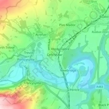
Name: Cefn Mawr topographic map, elevation, terrain.
Location: Cefn Mawr, Wrexham, Wales, LL14 3AS, United Kingdom (52.95314 -3.09215 52.99314 -3.05215)
Average elevation: 423 ft
Minimum elevation: 151 ft
Maximum elevation: 1,135 ft
Other topographic maps
Click on a map to view its topography, its elevation and its terrain.
Bryn Du (Y Fawnen)
United Kingdom > Wales > Wrexham
Bryn Du (Y Fawnen), Wrexham, Wales, LL20 7DD, United Kingdom
Average elevation: 1,480 ft
River Ceiriog
United Kingdom > Wales > Wrexham > Pandy
River Ceiriog, Pandy, Wrexham, Wales, United Kingdom, River Ceiriog
Average elevation: 308 ft
Chirk
United Kingdom > Wales > Wrexham
Chirk, Wrexham, Wales, LL14 5EZ, United Kingdom
Average elevation: 482 ft
Ruabon
United Kingdom > Wales > Wrexham
Ruabon, Wrexham, Wales, LL14 6DG, United Kingdom
Average elevation: 407 ft
Wrexham
United Kingdom > Wales > Wrexham
Wrexham, Wales, LL11 1AP, United Kingdom
Average elevation: 456 ft
Ridleywood
United Kingdom > Wales > Wrexham > Wrexham
Ridleywood, Holt, Wrexham, Wales, LL13 9US, United Kingdom
Average elevation: 75 ft