
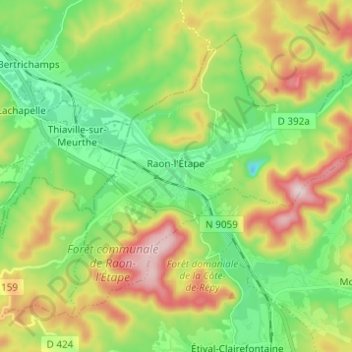
Raon-l'Étape topographic map
Interactive map
Click on the map to display elevation.
About this map
Name: Raon-l'Étape topographic map, elevation, terrain.
Average elevation: 1,188 ft
Minimum elevation: 719 ft
Maximum elevation: 1,982 ft
Raon-l'Étape is positioned at the mouth of the Plaine [fr] at the point where it converges into the Meurthe, itself a tributary of the Moselle. Because it is on departmental frontier with the adjacent Meurthe-et-Moselle département, Raon-l'Étape is sometimes known as the "Gateway to the Vosges" (porte des Vosges). The town is positioned at a point where relatively flat lands transform into a much more mountainous topography: the mountains have for centuries restricted the options for travellers between francophone France and Alsace (formerly the western reaches of the Empire on the other side of the Vosges). The position of Raon has therefore been critical to influencing the movements of merchandise in peace time and of armies in war time for many centuries.
Other topographic maps
Click on a map to view its topography, its elevation and its terrain.
Dogneville
Dogneville, Épinal, Vosges, Grand Est, Metropolitan France, 88000, France
Average elevation: 1,106 ft
Les Plombes
France > Grand Est > Vosges > Xonrupt-Longemer
Les Plombes, Xonrupt-Longemer, Saint-Dié-des-Vosges, Vosges, Grand Est, Metropolitan France, 88400, France
Average elevation: 2,894 ft
Les Sources
France > Grand Est > Vosges > Bussang
Les Sources, Bussang, Épinal, Vosges, Grand Est, Metropolitan France, 88540, France
Average elevation: 2,644 ft
Ramberchamp
France > Grand Est > Vosges > Gérardmer
Ramberchamp, Gérardmer, Saint-Dié-des-Vosges, Vosges, Grand Est, Metropolitan France, 88400, France
Average elevation: 2,579 ft
La Petite-Fosse
La Petite-Fosse, Saint-Dié-des-Vosges, Vosges, Grand Est, Metropolitan France, 88490, France
Average elevation: 1,854 ft
Maxey-sur-Meuse
Maxey-sur-Meuse, Neufchâteau, Vosges, Grand Est, Metropolitan France, 88630, France
Average elevation: 1,066 ft
La Vôge-les-Bains
France > Grand Est > Vosges > La Vôge-les-Bains
La Vôge-les-Bains, Épinal, Vosges, Grand Est, Metropolitan France, 88240, France
Average elevation: 1,243 ft
Bellefontaine
Bellefontaine, Épinal, Vosges, Grand Est, Metropolitan France, 88370, France
Average elevation: 1,785 ft
Neufchâteau
Neufchâteau, Vosges, Grand Est, Metropolitan France, 88300, France
Average elevation: 1,096 ft
La Croix-aux-Mines
La Croix-aux-Mines, Saint-Dié-des-Vosges, Vosges, Grand Est, Metropolitan France, 88520, France
Average elevation: 2,313 ft
Ménil-sur-Belvitte
Ménil-sur-Belvitte, Épinal, Vosges, Grand Est, Metropolitan France, 88700, France
Average elevation: 1,033 ft