
Goetsenhoven topographic map
Interactive map
Click on the map to display elevation.
About this map
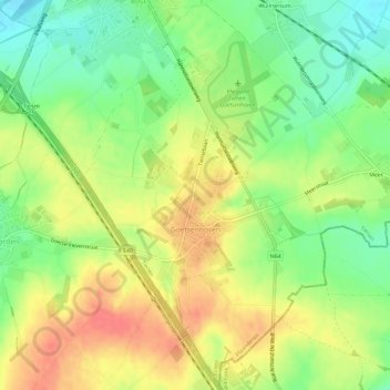
Name: Goetsenhoven topographic map, elevation, terrain.
Location: Goetsenhoven, Tienen, Leuven, Flemish Brabant, Belgium (50.75236 4.93189 50.78974 4.99036)
Average elevation: 236 ft
Minimum elevation: 141 ft
Maximum elevation: 328 ft
Other topographic maps
Click on a map to view its topography, its elevation and its terrain.
Tienen
Belgium > Flemish Brabant > Leuven > Tienen
Tienen, Leuven, Flemish Brabant, Flanders, 3300, Belgium
Average elevation: 184 ft