
Radford City topographic map
Interactive map
Click on the map to display elevation.
About this map
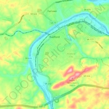
Name: Radford City topographic map, elevation, terrain.
Location: Radford City, Radford (city), Virginia, United States (37.08966 -80.59641 37.15091 -80.50792)
Average elevation: 1,916 ft
Minimum elevation: 1,690 ft
Maximum elevation: 2,300 ft
Other topographic maps
Click on a map to view its topography, its elevation and its terrain.
New Town
United States > Virginia > Radford (city) > Radford City
New Town, Radford City, Radford (city), Virginia, 24129, United States
Average elevation: 1,883 ft
Radford (city)
United States > Virginia > Radford (city)
Radford (city), Virginia, 24142, United States
Average elevation: 2,047 ft