
Homyel topographic map
Interactive map
Click on the map to display elevation.
About this map
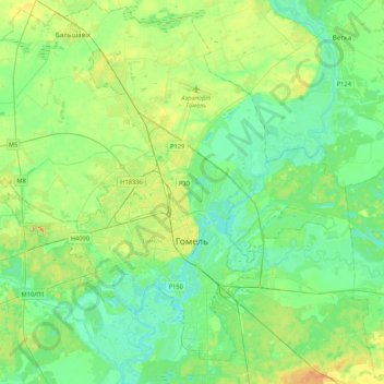
Name: Homyel topographic map, elevation, terrain.
Location: Homyel, Homyel Region, Belarus (52.34327 30.74695 52.57076 31.17153)
Average elevation: 427 ft
Minimum elevation: 358 ft
Maximum elevation: 610 ft
Other topographic maps
Click on a map to view its topography, its elevation and its terrain.
Пакалюбіцкі сельскі Савет
Belarus > Homyel Region > Homyel District
Пакалюбіцкі сельскі Савет, Homyel District, Homyel Region, 247017, Belarus
Average elevation: 436 ft
Косель
Belarus > Homyel Region > Karma District > Ліцвінавіцкі сельскі Савет
Косель, Ліцвінавіцкі сельскі Савет, Karma District, Homyel Region, Belarus
Average elevation: 492 ft
Zhlobin
Belarus > Homyel Region > Zhlobin District
Zhlobin, Zhlobin District, Homyel Region, Belarus
Average elevation: 440 ft
Mazyr
Belarus > Homyel Region > Mazyr District
Mazyr, Mazyr District, Homyel Region, Belarus
Average elevation: 459 ft
Лукский
Belarus > Homyel Region > Zhlobin District > Лукский сельский Совет > Лукский
Лукский, Лукский сельский Совет, Zhlobin District, Homyel Region, Belarus
Average elevation: 449 ft
Narowlya
Belarus > Homyel Region > Naroulia District
Narowlya, Naroulia District, Homyel Region, Belarus
Average elevation: 377 ft