
Sondershausen topographic map
Interactive map
Click on the map to display elevation.
About this map
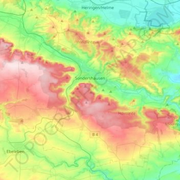
Name: Sondershausen topographic map, elevation, terrain.
Location: Sondershausen, Kyffhäuserkreis, Thuringia, 99706, Germany (51.28352 10.62026 51.42166 10.94949)
Average elevation: 896 ft
Minimum elevation: 472 ft
Maximum elevation: 1,522 ft
Other topographic maps
Click on a map to view its topography, its elevation and its terrain.
Sondershausen
Germany > Thuringia > Kyffhäuserkreis > Sondershausen > Sondershausen
Sondershausen, Kyffhäuserland, Kyffhäuserkreis, Thuringia, 99707, Germany
Average elevation: 958 ft