
Thuin topographic map
Interactive map
Click on the map to display elevation.
About this map
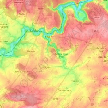
Name: Thuin topographic map, elevation, terrain.
Location: Thuin, Hainaut, Wallonia, Belgium (50.26727 4.22675 50.37683 4.39491)
Average elevation: 571 ft
Minimum elevation: 344 ft
Maximum elevation: 722 ft
Other topographic maps
Click on a map to view its topography, its elevation and its terrain.
Grand-Reng
Grand-Reng, Erquelinnes, Thuin, Hainaut, Wallonia, 6560, Belgium
Average elevation: 456 ft
Froidchapelle
Froidchapelle, Thuin, Hainaut, Wallonia, Belgium
Average elevation: 774 ft