
Pocahontas topographic map
Interactive map
Click on the map to display elevation.
About this map
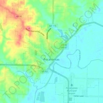
Name: Pocahontas topographic map, elevation, terrain.
Location: Pocahontas, Randolph County, Arkansas, United States (36.23428 -91.00607 36.29809 -90.93461)
Average elevation: 315 ft
Minimum elevation: 246 ft
Maximum elevation: 492 ft
Other topographic maps
Click on a map to view its topography, its elevation and its terrain.
Sand Hill
United States > Arkansas > Randolph County > Pocahontas
Sand Hill, Pocahontas, Randolph County, Arkansas, 72455, United States
Average elevation: 387 ft
Pocahontas
United States > Arkansas > Randolph County > Pocahontas
Pocahontas, Randolph County, Arkansas, 72455, United States
Average elevation: 308 ft