
Einsiedeln topographic map
Interactive map
Click on the map to display elevation.
About this map
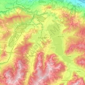
Name: Einsiedeln topographic map, elevation, terrain.
Location: Einsiedeln, Schwyz, 8840, Switzerland (47.06327 8.68420 47.17828 8.88661)
Average elevation: 3,356 ft
Minimum elevation: 1,352 ft
Maximum elevation: 5,217 ft
Einsiedeln is located approximately 7.5 km (4.7 mi) from the southern end of the Lake of Zurich, and 2 km (1.2 mi) west of the artificial Sihlsee lake. It is on a plateau (ca. 880 m (2,890 ft) above sea level). The town is located at an altitude of 470 m (1,540 ft) higher than Zurich, with which it has a railway connection.