
Cerro Las Minas topographic map
Interactive map
Click on the map to display elevation.
About this map
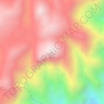
Name: Cerro Las Minas topographic map, elevation, terrain.
Location: Cerro Las Minas, Gracias, Lempira, Honduras (14.53360 -88.68013 14.53370 -88.68003)
Average elevation: 8,304 ft
Minimum elevation: 6,404 ft
Maximum elevation: 9,288 ft
Other topographic maps
Click on a map to view its topography, its elevation and its terrain.
Parque Nacional Celaque
Parque Nacional Celaque, Gracias, Lempira, Honduras
Average elevation: 5,771 ft