
Greven topographic map
Interactive map
Click on the map to display elevation.
About this map
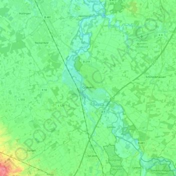
Name: Greven topographic map, elevation, terrain.
Location: Greven, Kreis Steinfurt, North Rhine-Westphalia, 48268, Germany (52.03256 7.52337 52.15176 7.75559)
Average elevation: 161 ft
Minimum elevation: 108 ft
Maximum elevation: 328 ft
Other topographic maps
Click on a map to view its topography, its elevation and its terrain.
Nordwalde
Germany > North Rhine-Westphalia > Kreis Steinfurt
Nordwalde, Kreis Steinfurt, North Rhine-Westphalia, 48356, Germany
Average elevation: 177 ft