
Georgetown topographic map
Interactive map
Click on the map to display elevation.
About this map
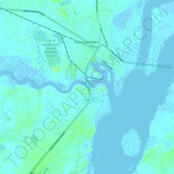
Name: Georgetown topographic map, elevation, terrain.
Location: Georgetown, Georgetown County, South Carolina, United States (33.31723 -79.32317 33.39550 -79.26659)
Average elevation: 7 ft
Minimum elevation: -20 ft
Maximum elevation: 79 ft
Other topographic maps
Click on a map to view its topography, its elevation and its terrain.
Georgetown
United States > South Carolina > Georgetown County > Georgetown
Georgetown, Georgetown County, South Carolina, 29440, United States
Average elevation: 10 ft
Country Club Estates
United States > South Carolina > Georgetown County > Georgetown > Country Club Estates
Country Club Estates, Georgetown, Georgetown County, South Carolina, 29440, United States
Average elevation: 10 ft