
Izagaondoa topographic map
Interactive map
Click on the map to display elevation.
About this map
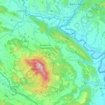
Name: Izagaondoa topographic map, elevation, terrain.
Location: Izagaondoa, Pirinioaurrea / Prepirineo, Espagne (42.67587 -1.51857 42.78171 -1.34913)
Average elevation: 2,037 ft
Minimum elevation: 1,424 ft
Maximum elevation: 4,429 ft
Other topographic maps
Click on a map to view its topography, its elevation and its terrain.
Ardanaz de Izagaondoa
Espagne > Pirinioaurrea / Prepirineo > Izagaondoa
Ardanaz de Izagaondoa, Izagaondoa, Pirinioaurrea / Prepirineo, Espagne
Average elevation: 2,349 ft