
Beverīnas novads topographic map
Interactive map
Click on the map to display elevation.
About this map
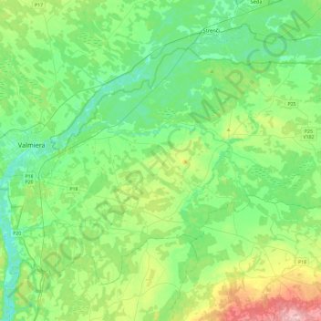
Name: Beverīnas novads topographic map, elevation, terrain.
Location: Beverīnas novads, Valmieras novads, Vidzeme, Latvia (57.43053 25.37713 57.62235 25.84113)
Average elevation: 207 ft
Minimum elevation: 82 ft
Maximum elevation: 564 ft
Other topographic maps
Click on a map to view its topography, its elevation and its terrain.
Valmiera
Latvia > Vidzeme > Valmieras novads
Valmiera, Valmieras novads, Vidzeme, Latvia
Average elevation: 164 ft