
Kusel topographic map
Interactive map
Click on the map to display elevation.
About this map
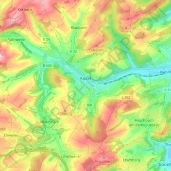
Name: Kusel topographic map, elevation, terrain.
Average elevation: 1,020 ft
Minimum elevation: 676 ft
Maximum elevation: 1,401 ft
Other topographic maps
Click on a map to view its topography, its elevation and its terrain.
Rathsweiler
Germany > Rhineland-Palatinate > Landkreis Kusel
Rathsweiler, Kusel-Altenglan, Landkreis Kusel, Rhineland-Palatinate, Germany
Average elevation: 879 ft