
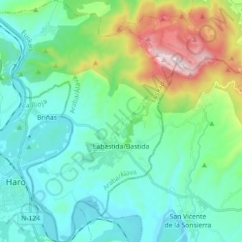
Labastida/Bastida topographic map
Interactive map
Click on the map to display elevation.
About this map
Name: Labastida/Bastida topographic map, elevation, terrain.
Average elevation: 2,005 ft
Minimum elevation: 1,388 ft
Maximum elevation: 4,108 ft
The town is at 529m altitude, and is positioned between the River Ebro and the Sierra de Toloño mountain range.
Other topographic maps
Click on a map to view its topography, its elevation and its terrain.
Salinillas de Buradón/Gatzaga Buradon
Spain > Autonomous Community of the Basque Country > Arabako Errioxa/Rioja Alavesa > Labastida/Bastida
Salinillas de Buradón/Gatzaga Buradon, Labastida/Bastida, Arabako Errioxa/Rioja Alavesa, Álava, Autonomous Community of the Basque Country, Spain
Average elevation: 1,965 ft
Laguardia
Spain > Autonomous Community of the Basque Country > Arabako Errioxa/Rioja Alavesa
Laguardia, Arabako Errioxa/Rioja Alavesa, Álava, Autonomous Community of the Basque Country, Spain
Average elevation: 1,942 ft
Oyón/Oion
Spain > Autonomous Community of the Basque Country > Arabako Errioxa/Rioja Alavesa
Oyón/Oion, Arabako Errioxa/Rioja Alavesa, Álava, Autonomous Community of the Basque Country, 01320, Spain
Average elevation: 1,877 ft