
Queilen topographic map
Interactive map
Click on the map to display elevation.
About this map
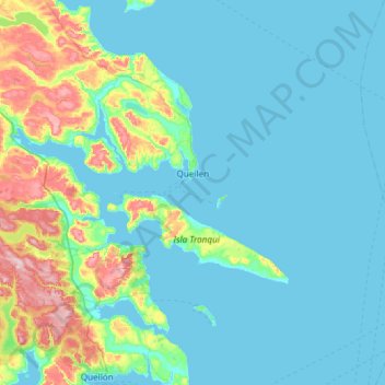
Name: Queilen topographic map, elevation, terrain.
Location: Queilen, Provincia de Chiloé, Los Lagos Region, Chile (-43.10521 -73.74881 -42.71990 -73.15294)
Average elevation: 138 ft
Minimum elevation: -3 ft
Maximum elevation: 856 ft
Other topographic maps
Click on a map to view its topography, its elevation and its terrain.
Villa Mechuque
Chile > Los Lagos Region > Provincia de Chiloé > Quemchi
Villa Mechuque, Quemchi, Provincia de Chiloé, Los Lagos Region, Chile
Average elevation: 141 ft
Isla Lacao
Chile > Los Lagos Region > Provincia de Chiloé > Ancud
Isla Lacao, Ancud, Provincia de Chiloé, Los Lagos Region, Chile
Average elevation: 7 ft