
Distrito Macaracas topographic map
Interactive map
Click on the map to display elevation.
About this map
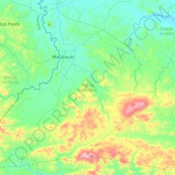
Name: Distrito Macaracas topographic map, elevation, terrain.
Location: Distrito Macaracas, Los Santos, Panamá (7.54030 -80.71965 7.81653 -80.41410)
Average elevation: 801 ft
Minimum elevation: 69 ft
Maximum elevation: 3,002 ft
Other topographic maps
Click on a map to view its topography, its elevation and its terrain.
Distrito Las Tablas
Distrito Las Tablas, Los Santos, Panamá
Average elevation: 568 ft
Distrito Los Santos
Distrito Los Santos, Los Santos, Panamá
Average elevation: 180 ft