
Trent Valley topographic map
Interactive map
Click on the map to display elevation.
About this map
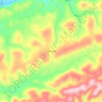
Name: Trent Valley topographic map, elevation, terrain.
Location: Trent Valley, Hancock County, Tennessee, United States (36.47759 -83.21212 36.51759 -83.17212)
Average elevation: 1,621 ft
Minimum elevation: 1,119 ft
Maximum elevation: 2,060 ft
Other topographic maps
Click on a map to view its topography, its elevation and its terrain.
Independence
United States > Tennessee > Hancock County
Independence, Hancock County, East Tennessee, Tennessee, United States
Average elevation: 1,575 ft
Sneedville
United States > Tennessee > Hancock County
Sneedville, Hancock County, East Tennessee, Tennessee, United States
Average elevation: 1,555 ft