
Shawnee Hills topographic map
Interactive map
Click on the map to display elevation.
About this map
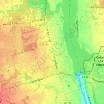
Name: Shawnee Hills topographic map, elevation, terrain.
Location: Shawnee Hills, Delaware County, Ohio, United States (40.15241 -83.14507 40.16693 -83.12833)
Average elevation: 889 ft
Minimum elevation: 778 ft
Maximum elevation: 958 ft
Other topographic maps
Click on a map to view its topography, its elevation and its terrain.
Porter Township
United States > Ohio > Delaware County
Porter Township, Delaware County, Ohio, United States
Average elevation: 1,115 ft
Lewis Center
United States > Ohio > Delaware County
Lewis Center, Orange Township, Delaware County, Ohio, 43035, United States
Average elevation: 938 ft
Ostrander
United States > Ohio > Delaware County
Ostrander, Scioto Township, Delaware County, Ohio, United States
Average elevation: 938 ft
Radnor
United States > Ohio > Delaware County
Radnor, Radnor Township, Delaware County, Ohio, 43066, United States
Average elevation: 932 ft
Kilbourne
United States > Ohio > Delaware County
Kilbourne, Brown Township, Delaware County, Ohio, 43032, United States
Average elevation: 948 ft
Ashley
United States > Ohio > Delaware County
Ashley, Oxford Township, Delaware County, Ohio, United States
Average elevation: 978 ft
Concord Township
United States > Ohio > Delaware County
Concord Township, Delaware County, Ohio, United States
Average elevation: 932 ft
Berkshire
United States > Ohio > Delaware County
Berkshire, Berkshire Township, Delaware County, Ohio, 40321, United States
Average elevation: 958 ft
Orange Township
United States > Ohio > Delaware County
Orange Township, Delaware County, Ohio, 43035, United States
Average elevation: 912 ft
Galena
United States > Ohio > Delaware County
Galena, Berkshire Township, Delaware County, Ohio, United States
Average elevation: 935 ft
Sunbury
United States > Ohio > Delaware County
Sunbury, Delaware County, Ohio, United States
Average elevation: 984 ft
Center Green Park
United States > Ohio > Delaware County > Maxtown
Center Green Park, Maxtown, Genoa Township, Delaware County, Ohio, United States
Average elevation: 909 ft
Scioto
United States > Ohio > Delaware County > Scioto
Scioto, Scioto Township, Delaware County, Ohio, 43061, United States
Average elevation: 925 ft
Genoa Township
United States > Ohio > Delaware County
Genoa Township, Delaware County, Ohio, United States
Average elevation: 922 ft
Powell
United States > Ohio > Delaware County
Powell, Liberty Township, Delaware County, Ohio, United States
Average elevation: 899 ft
Delaware
United States > Ohio > Delaware County
Delaware, Delaware County, Ohio, 43015, United States
Average elevation: 935 ft
East Liberty
United States > Ohio > Delaware County
East Liberty, Porter Township, Delaware County, Ohio, United States
Average elevation: 1,096 ft