
Zanskar topographic map
Interactive map
Click on the map to display elevation.
About this map
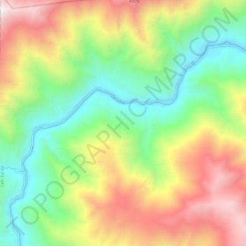
Name: Zanskar topographic map, elevation, terrain.
Location: Zanskar, Leh, Leh District, Jammu and Kashmir, India (34.09342 77.21041 34.14424 77.30293)
Average elevation: 12,904 ft
Minimum elevation: 10,210 ft
Maximum elevation: 16,831 ft
Other topographic maps
Click on a map to view its topography, its elevation and its terrain.
Ladakh Range
India > Jammu and Kashmir > Leh
Ladakh Range, Leh, Leh District, Jammu and Kashmir, India
Average elevation: 16,194 ft
Stok Kangri
India > Jammu and Kashmir > Leh
Stok Kangri, Leh, Leh District, Jammu and Kashmir, India
Average elevation: 18,251 ft
Nubra
India > Jammu and Kashmir > Leh
Nubra, Leh, Leh District, Jammu and Kashmir, India
Average elevation: 10,515 ft