
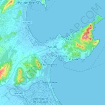
Alcúdia topographic map
Interactive map
Click on the map to display elevation.
About this map
Name: Alcúdia topographic map, elevation, terrain.
Location: Alcúdia, Raiguer, Balearic Islands, Spain (39.79893 3.03563 39.89336 3.20450)
Average elevation: 66 ft
Minimum elevation: -16 ft
Maximum elevation: 1,391 ft
Other topographic maps
Click on a map to view its topography, its elevation and its terrain.
es Pla de na Tesa
Spain > Balearic Islands > Raiguer > Marratxí
es Pla de na Tesa, Marratxí, Raiguer, Balearic Islands, 07141, Spain
Average elevation: 131 ft
sa Pobla
Spain > Balearic Islands > Raiguer > sa Pobla
sa Pobla, Raiguer, Balearic Islands, 07420, Spain
Average elevation: 171 ft