
Manta topographic map
Interactive map
Click on the map to display elevation.
About this map
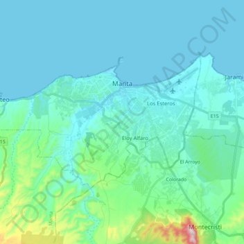
Name: Manta topographic map, elevation, terrain.
Location: Manta, Manabí, Ecuador (-1.02264 -80.83747 -0.92891 -80.66398)
Average elevation: 253 ft
Minimum elevation: -7 ft
Maximum elevation: 1,969 ft
Other topographic maps
Click on a map to view its topography, its elevation and its terrain.
Barbasquillo
Ecuador > Manabí > Manta > Manta
Barbasquillo, Ciudadela Universitaria, Manta Central, Manta, Manabí, Ecuador
Average elevation: 75 ft
Cevicheria Umiña
Cevicheria Umiña, Manta, Manabí, 130214, Ecuador
Average elevation: 85 ft
Las Orquideas
Ecuador > Manabí > Manta > Manta
Las Orquideas, Ciudadela Aurora, Manta, Manabí, Ecuador
Average elevation: 157 ft