
Rewari topographic map
Interactive map
Click on the map to display elevation.
About this map
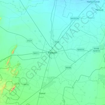
Name: Rewari topographic map, elevation, terrain.
Location: Rewari, Rewari District, Haryana, 123110, India (28.03565 76.45652 28.35565 76.77652)
Average elevation: 817 ft
Minimum elevation: 738 ft
Maximum elevation: 1,542 ft
Rewari is located at 28°11′N 76°37′E / 28.18°N 76.62°E / 28.18; 76.62. It has an average elevation of 245 metres (803 feet). Rewari is 85 km away from Delhi.
Other topographic maps
Click on a map to view its topography, its elevation and its terrain.