
El Torno topographic map
Interactive map
Click on the map to display elevation.
About this map
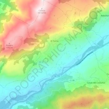
Name: El Torno topographic map, elevation, terrain.
Location: El Torno, Valle del Jerte, Cáceres, Extremadura, Spain (40.08895 -6.00005 40.16455 -5.91007)
Average elevation: 2,523 ft
Minimum elevation: 1,184 ft
Maximum elevation: 4,852 ft
El Torno is a small village at the west of Spain. It is a mountains village, and has a river named Jerte. The village is at 900 m altitude. The main monument is an old church. It is an agriculture village, and its main fruit is the cherry. It is rainy and has much forest. The more important holiday is San Lucas on October 18, and also the Carnival is very important.[citation needed]