Abali RD topographic map
Interactive map
Click on the map to display elevation.
About this map
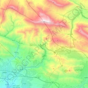
Name: Abali RD topographic map, elevation, terrain.
Average elevation: 8,048 ft
Minimum elevation: 5,354 ft
Maximum elevation: 12,103 ft

Click on the map to display elevation.
Name: Abali RD topographic map, elevation, terrain.
Average elevation: 8,048 ft
Minimum elevation: 5,354 ft
Maximum elevation: 12,103 ft