
Cantón Zarcero topographic map
Interactive map
Click on the map to display elevation.
About this map
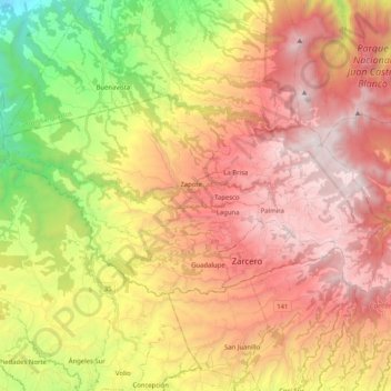
Name: Cantón Zarcero topographic map, elevation, terrain.
Location: Cantón Zarcero, Alajuela Province, Costa Rica (10.16725 -84.51826 10.27042 -84.31406)
Average elevation: 4,498 ft
Minimum elevation: 814 ft
Maximum elevation: 7,530 ft
Other topographic maps
Click on a map to view its topography, its elevation and its terrain.
Carrillos Bajo
Costa Rica > Alajuela Province > Cantón Poás > Carrillos > Carrillos Bajo
Carrillos Bajo, Carrillos, Cantón Poás, Alajuela Province, 20804, Costa Rica
Average elevation: 2,736 ft
Los Chiles
Costa Rica > Alajuela Province > Cantón Los Chiles > Los Chiles
Los Chiles, Cantón Los Chiles, Alajuela Province, 21401, Costa Rica
Average elevation: 128 ft
Venecia
Costa Rica > Alajuela Province > Venecia
Venecia, Cantón San Carlos, Alajuela Province, 21005, Costa Rica
Average elevation: 2,415 ft
San Juan
Costa Rica > Alajuela Province > San Juan
San Juan, Cantón Poás, Alajuela Province, 20802, Costa Rica
Average elevation: 5,476 ft