
Serro topographic map
Interactive map
Click on the map to display elevation.
About this map
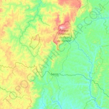
Name: Serro topographic map, elevation, terrain.
Average elevation: 3,150 ft
Minimum elevation: 2,037 ft
Maximum elevation: 6,703 ft
Other topographic maps
Click on a map to view its topography, its elevation and its terrain.
Milho Verde
Brazil > Minas Gerais > Serro
Milho Verde, Serro, Região Geográfica Imediata de Diamantina, Região Geográfica Intermediária de Teófilo Otoni, Minas Gerais, Southeast Region, 39150-000, Brazil
Average elevation: 3,550 ft