
Eberswalde topographic map
Interactive map
Click on the map to display elevation.
About this map
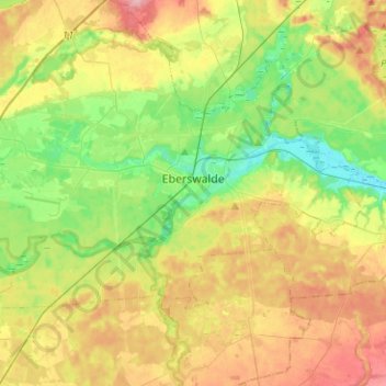
Name: Eberswalde topographic map, elevation, terrain.
Location: Eberswalde, Barnim, Brandenburg, Germany (52.77643 13.65766 52.88220 13.91021)
Average elevation: 174 ft
Minimum elevation: 13 ft
Maximum elevation: 390 ft
Other topographic maps
Click on a map to view its topography, its elevation and its terrain.
Stolzenhagen
Germany > Brandenburg > Barnim > Lunow-Stolzenhagen
Stolzenhagen, Lunow-Stolzenhagen, Britz-Chorin-Oderberg, Barnim, Brandenburg, 16248, Germany
Average elevation: 92 ft
Bernau
Germany > Brandenburg > Barnim
Bernau, Barnim, Brandenburg, 16321, Germany
Average elevation: 236 ft