
Austin topographic map
Interactive map
Click on the map to display elevation.
About this map
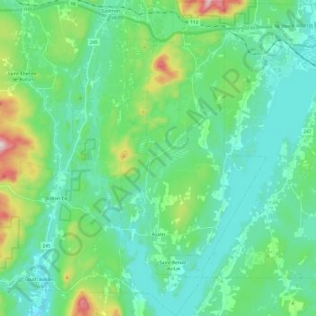
Name: Austin topographic map, elevation, terrain.
Location: Austin, Memphrémagog, Estrie, Québec, J0B 1B0, Canada (45.14112 -72.30834 45.30669 -72.19943)
Average elevation: 951 ft
Minimum elevation: 600 ft
Maximum elevation: 2,287 ft
Other topographic maps
Click on a map to view its topography, its elevation and its terrain.
Mont Orford
Canada > Québec > Memphrémagog > Orford
Mont Orford, Orford, Memphrémagog, Estrie, Québec, J1X 0R4, Canada
Average elevation: 1,834 ft
Lac Memphrémagog
Canada > Québec > Memphrémagog > Magog
Lac Memphrémagog, Magog, Memphrémagog, Estrie, Québec, J2L 2V8, Canada
Average elevation: 702 ft
Stanstead (Ville)
Canada > Québec > Memphrémagog > Stanstead (Ville)
Stanstead (Ville), Memphrémagog, Estrie, Québec, Canada
Average elevation: 1,066 ft
Sainte-Catherine-de-Hatley
Canada > Québec > Memphrémagog > Sainte-Catherine-de-Hatley
Sainte-Catherine-de-Hatley, Memphrémagog, Estrie, Québec, J0B 1W0, Canada
Average elevation: 801 ft
Magog
Canada > Québec > Memphrémagog
Magog, Memphrémagog, Estrie, Québec, Canada
Average elevation: 820 ft
Bolton-Est
Canada > Québec > Memphrémagog
Bolton-Est, Memphrémagog, Estrie, Québec, J0E 1G0, Canada
Average elevation: 1,053 ft