
Reinfeld topographic map
Interactive map
Click on the map to display elevation.
About this map
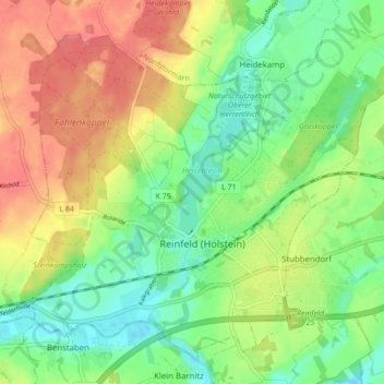
Name: Reinfeld topographic map, elevation, terrain.
Location: Reinfeld, Stormarn, Schleswig-Holstein, 23858, Germany (53.81458 10.44486 53.85889 10.53086)
Average elevation: 98 ft
Minimum elevation: -3 ft
Maximum elevation: 223 ft
Other topographic maps
Click on a map to view its topography, its elevation and its terrain.
Ahrensburg
Germany > Schleswig-Holstein > Stormarn
Ahrensburg, Stormarn, Schleswig-Holstein, 22926, Germany
Average elevation: 148 ft
Bad Oldesloe
Germany > Schleswig-Holstein > Stormarn
Bad Oldesloe, Stormarn, Schleswig-Holstein, 23843, Germany
Average elevation: 98 ft