
San Adrián topographic map
Interactive map
Click on the map to display elevation.
About this map
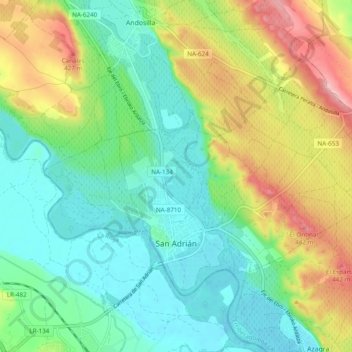
Name: San Adrián topographic map, elevation, terrain.
Location: San Adrián, Ribera Estellesa, Navarra, 31570, España (42.32219 -1.97000 42.37057 -1.87349)
Average elevation: 1,125 ft
Minimum elevation: 942 ft
Maximum elevation: 1,490 ft
Other topographic maps
Click on a map to view its topography, its elevation and its terrain.
Esparraguera
España > Navarra > Ribera Estellesa > Andosilla
Esparraguera, Andosilla, Ribera Estellesa, Navarra, España
Average elevation: 1,109 ft