
San Pascual topographic map
Interactive map
Click on the map to display elevation.
About this map
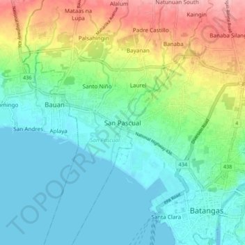
Name: San Pascual topographic map, elevation, terrain.
Location: San Pascual, Batangas, Calabarzon, 4204, Philippines (13.74449 120.99022 13.82449 121.07022)
Average elevation: 135 ft
Minimum elevation: -3 ft
Maximum elevation: 466 ft
Other topographic maps
Click on a map to view its topography, its elevation and its terrain.
Santo Niño
Philippines > Batangas > San Pascual > Santo Niño
Santo Niño, San Pascual, Batangas, Calabarzon, 4204, Philippines
Average elevation: 148 ft