
Hayden Valley topographic map
Interactive map
Click on the map to display elevation.
About this map
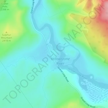
Name: Hayden Valley topographic map, elevation, terrain.
Location: Hayden Valley, Park County, Wyoming, United States (44.63362 -110.46622 44.65362 -110.44622)
Average elevation: 7,785 ft
Minimum elevation: 7,674 ft
Maximum elevation: 8,140 ft
A grassy valley, branching between low ridges, running from the river toward the center of the basin. A small stream rose in this valley, breaking through the ridges to the west in a deep cañon, and falling into the channel of the Yellowstone, which here bears in a northeast course, flowing in view as far as the confluence of the small stream, thence plunged into the Grand Cañon, and hidden from sight. No falls can be seen, but their location is readily detected by the sudden disappearance of the river; beyond this open valley the basin appears to be filled with a succession of low, converging ridges, heavily timbered, and all of about an equal altitude. To the south appears a broad sheet of water -- the Yellowstone Lake.
Other topographic maps
Click on a map to view its topography, its elevation and its terrain.
Yellowstone National Park
United States > Wyoming > Park County
Yellowstone National Park, Park County, Wyoming, United States
Average elevation: 8,038 ft
Canyon Village
United States > Wyoming > Park County
Canyon Village, Park County, Wyoming, 82190, United States
Average elevation: 7,933 ft
Dome Mountain
United States > Wyoming > Park County
Dome Mountain, Park County, Wyoming, United States
Average elevation: 8,684 ft
Mount Everts
United States > Wyoming > Park County
Mount Everts, Park County, Wyoming, United States
Average elevation: 7,192 ft
Clark
United States > Wyoming > Park County
Clark, Park County, Wyoming, United States
Average elevation: 4,229 ft
Obsidian Cliff
United States > Wyoming > Park County
Obsidian Cliff, Park County, Wyoming, United States
Average elevation: 7,746 ft
Mount Washburn
United States > Wyoming > Park County
Mount Washburn, Park County, Wyoming, United States
Average elevation: 9,180 ft
Sunlight Bridge Overlook
United States > Wyoming > Park County
Sunlight Bridge Overlook, Chief Joseph Highway, Park County, Wyoming, United States
Average elevation: 6,302 ft
Cody
United States > Wyoming > Park County
Cody, Park County, Wyoming, United States
Average elevation: 5,108 ft
Inspiration Point
United States > Wyoming > Park County
Inspiration Point, North Rim Trail, Park County, Wyoming, 82190, United States
Average elevation: 7,766 ft
Powell
United States > Wyoming > Park County > Powell
Powell, Park County, Wyoming, United States
Average elevation: 4,564 ft
Meeteetse
United States > Wyoming > Park County
Meeteetse, Park County, Wyoming, United States
Average elevation: 5,876 ft
Wapiti
United States > Wyoming > Park County
Wapiti, Park County, Wyoming, 82450, United States
Average elevation: 5,886 ft