
Lily Lake topographic map
Interactive map
Click on the map to display elevation.
About this map
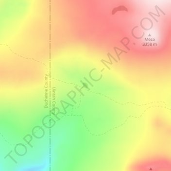
Name: Lily Lake topographic map, elevation, terrain.
Location: Lily Lake, Uintah County, Utah, United States (40.68258 -109.96973 40.68355 -109.96860)
Average elevation: 10,479 ft
Minimum elevation: 9,806 ft
Maximum elevation: 11,020 ft
Other topographic maps
Click on a map to view its topography, its elevation and its terrain.
Naples
United States > Utah > Uintah County
Naples, Uintah County, Utah, United States
Average elevation: 5,233 ft
Randlett
United States > Utah > Uintah County
Randlett, Uintah County, Utah, 84063, United States
Average elevation: 4,872 ft
Ballard
United States > Utah > Uintah County
Ballard, Uintah County, Utah, United States
Average elevation: 5,089 ft
Uinta River
United States > Utah > Uintah County
Uinta River, Uintah County, Utah, 84026, United States
Average elevation: 5,069 ft
Vernal
United States > Utah > Uintah County
Vernal, Uintah County, Utah, United States
Average elevation: 5,331 ft
Jensen
United States > Utah > Uintah County > Jensen
Jensen, Uintah County, Utah, 84035, United States
Average elevation: 4,823 ft