
Markey Township topographic map
Interactive map
Click on the map to display elevation.
About this map
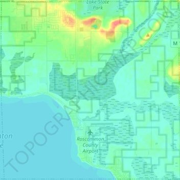
Name: Markey Township topographic map, elevation, terrain.
Location: Markey Township, Roscommon County, Michigan, United States (44.33439 -84.73550 44.42130 -84.61242)
Average elevation: 1,152 ft
Minimum elevation: 1,122 ft
Maximum elevation: 1,299 ft
Other topographic maps
Click on a map to view its topography, its elevation and its terrain.
Prudenville
United States > Michigan > Roscommon County
Prudenville, Denton Township, Roscommon County, Michigan, 48651, United States
Average elevation: 1,152 ft
Houghton Lake
United States > Michigan > Roscommon County > Houghton Lake
Houghton Lake, Roscommon Township, Roscommon County, Michigan, 48630, United States
Average elevation: 1,145 ft
Higgins Lake
United States > Michigan > Roscommon County
Higgins Lake, Lyon Township, Roscommon County, Michigan, United States
Average elevation: 1,171 ft
Roscommon Township
United States > Michigan > Roscommon County
Roscommon Township, Roscommon County, Michigan, United States
Average elevation: 1,138 ft
St. Helen
United States > Michigan > Roscommon County
St. Helen, Richfield Township, Roscommon County, Michigan, 48656, United States
Average elevation: 1,194 ft