
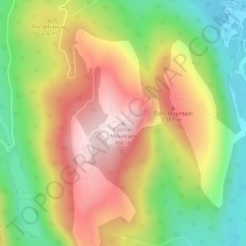
Cadillac Mountain topographic map
Interactive map
Click on the map to display elevation.
About this map
Name: Cadillac Mountain topographic map, elevation, terrain.
Average elevation: 764 ft
Minimum elevation: 49 ft
Maximum elevation: 1,512 ft
Cadillac Mountain is located on Mount Desert Island, within Acadia National Park, in the U.S. state of Maine. With an elevation of 1,530 feet (470 meters), its summit is the highest point in Hancock County and the highest within 25 miles (40 km) of the Atlantic shoreline of the North American continent between the Cape Breton Highlands, Nova Scotia, and peaks in Mexico. It is known as the first place in the continental U.S. to see the sunrise, although that is only true for a portion of the year.
Other topographic maps
Click on a map to view its topography, its elevation and its terrain.
Acadia National Park
United States > Maine > Hancock County > Bar Harbor
Acadia National Park, Bar Harbor, Hancock County, Maine, 04609, United States
Average elevation: 30 ft
Fresh Meadow
United States > Maine > Hancock County > Bar Harbor
Fresh Meadow, Bar Harbor, Hancock County, Maine, United States
Average elevation: 56 ft
Salsbury Cove
United States > Maine > Hancock County > Bar Harbor
Salsbury Cove, Bar Harbor, Hancock County, Maine, United States
Average elevation: 49 ft