
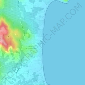
Plage de Pampelonne topographic map
Interactive map
Click on the map to display elevation.
About this map
Name: Plage de Pampelonne topographic map, elevation, terrain.
Average elevation: 49 ft
Minimum elevation: -3 ft
Maximum elevation: 427 ft
Other topographic maps
Click on a map to view its topography, its elevation and its terrain.
L'Escalet
France > Provence-Alpes-Côte d'Azur > Var > Ramatuelle
L'Escalet, Ramatuelle, Draguignan, Var, Provence-Alpes-Côte d'Azur, France métropolitaine, 83350, France
Average elevation: 125 ft
Paillas
France > Provence-Alpes-Côte d'Azur > Var > Ramatuelle
Paillas, Ramatuelle, Draguignan, Var, Provence-Alpes-Côte d'Azur, France métropolitaine, 83350, France
Average elevation: 358 ft
La Grangue
France > Provence-Alpes-Côte d'Azur > Var > Ramatuelle
La Grangue, Ramatuelle, Draguignan, Var, Provence-Alpes-Côte d'Azur, France métropolitaine, 83350, France
Average elevation: 108 ft
Phare du Cap Camarat
France > Provence-Alpes-Côte d'Azur > Var > Ramatuelle
Phare du Cap Camarat, Sentier Littoral, Ramatuelle, Draguignan, Var, Provence-Alpes-Côte d'Azur, France métropolitaine, 83350, France
Average elevation: 59 ft