
High Uintas Wilderness topographic map
Interactive map
Click on the map to display elevation.
About this map
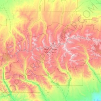
Name: High Uintas Wilderness topographic map, elevation, terrain.
Average elevation: 9,577 ft
Minimum elevation: 5,896 ft
Maximum elevation: 13,465 ft
Other topographic maps
Click on a map to view its topography, its elevation and its terrain.
Fruitland
United States > Utah > Duchesne County
Fruitland, Duchesne County, Utah, 84027, United States
Average elevation: 6,654 ft
Starvation State Park
United States > Utah > Duchesne County
Starvation State Park, Duchesne County, Utah, United States
Average elevation: 5,860 ft
Roosevelt
United States > Utah > Duchesne County
Roosevelt, Duchesne County, Utah, 84066, United States
Average elevation: 5,095 ft
Kings Peak
United States > Utah > Duchesne County
Kings Peak, Duchesne County, Utah, United States
Average elevation: 12,280 ft