
Sluispark topographic map
Interactive map
Click on the map to display elevation.
About this map
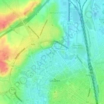
Name: Sluispark topographic map, elevation, terrain.
Location: Sluispark, Vaartkom, Leuven, Vlaams-Brabant, 3000, België (50.88626 4.69867 50.88699 4.70111)
Average elevation: 112 ft
Minimum elevation: 46 ft
Maximum elevation: 243 ft
Other topographic maps
Click on a map to view its topography, its elevation and its terrain.
Voer
België > Vlaams-Brabant > Leuven
Voer, Janseniushof, Leuven, Vlaams-Brabant, Vlaanderen, 3000, België
Average elevation: 121 ft