
Wolf River topographic map
Interactive map
Click on the map to display elevation.
About this map
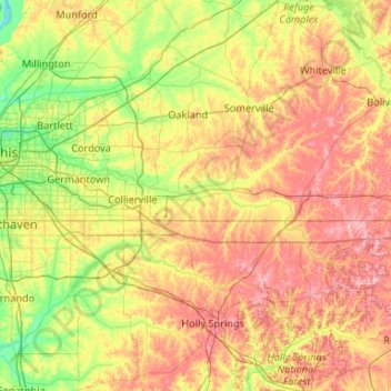
Name: Wolf River topographic map, elevation, terrain.
Average elevation: 400 ft
Minimum elevation: 194 ft
Maximum elevation: 728 ft
Other topographic maps
Click on a map to view its topography, its elevation and its terrain.
Laconia
United States > Tennessee > Fayette County
Laconia, Fayette County, West Tennessee, Tennessee, 38045, United States
Average elevation: 427 ft
La Grange
United States > Tennessee > Fayette County
La Grange, Fayette County, West Tennessee, Tennessee, United States
Average elevation: 489 ft