
San Pedro Garza García topographic map
Interactive map
Click on the map to display elevation.
About this map
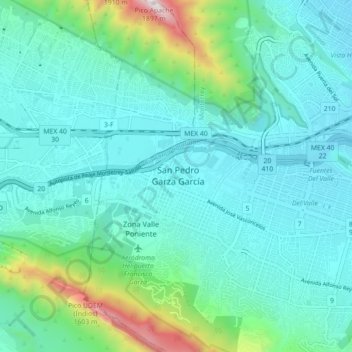
Name: San Pedro Garza García topographic map, elevation, terrain.
Location: San Pedro Garza García, Nuevo León, 66210, Mexico (25.62511 -100.44227 25.70511 -100.36227)
Average elevation: 2,618 ft
Minimum elevation: 1,857 ft
Maximum elevation: 6,132 ft
Other topographic maps
Click on a map to view its topography, its elevation and its terrain.
Villa Montaña Campestre
Mexico > Nuevo León > San Pedro Garza García
Villa Montaña Campestre, San Pedro Garza García, Nuevo León, 66230, Mexico
Average elevation: 3,176 ft